Maqâm Nabî Samwîl (n.d.)
Localisation
A 7km au nord de Jérusalem, route 436, actuel Park Nebi Samuel.
Bibliographie
Ayalon/Tal/Yehuda (2013), p.259-291 ; Conder/Kitchener (1883), III, p.149-153 (gravure) ; Corpus Christians Sites I (2012), p.289-291 ; Feldstein/Kidron (2012), n°53 ; Greenberg/Keinan (2009), n°382 ; Guérin (1868), I, p.362-384 ; Mieszko-Briks (2021), p.519-546 ; MWNF (2004), p.153-154 ; Naaman (2019), p.202-217 ; Petersen (2001c), p.359-382 ; Petersen (2018), p.134 ; Pringle (1998), n°159 ; Savignac/Abel (1912), p.267-279 ; Sharon (2004), p.114-134 ; Vincent (1922), p.360-402
Historique
Le site se situe à 7km au nord-ouest de Jérusalem, à une altitude de 908m, c’est un point culminant qui surplombe la ville et ses alentours, confondu avec Ramah de la Bible ou Mitzpa[1], le site a connu d’intenses phases de constructions Hellénistique, Byzantine et Croisée. Il ne semble pas avoir de traces de structures pré-hellénistiques.
Un quartier Hellénistique a été découvert après fouilles au sud-est du site, il regroupe des installations industrielles (fours, ateliers, presses à vin) et des habitations (ill.7-13).
Une grotte identifiée comme le lieu d’inhumation du prophète Samuel est recouverte d’une construction byzantine au 5e siècle. Des fouilles ont permit la découverte de nombreuses habitations et bâtiments industriels. En 553-554, sous le règne de l’empereur byzantin Justinien I (r.527-565) un monastère est construit avec un puit et un mur d’enceinte.
Après la conquête Musulmane en 636, le village byzantin continue à être habité, puis le site semble disparaître des sources.
Lors de 1e Croisade à partir de 1099, le site est connu sous le nom de Montjoie[2], les Croisés construisent une structure qui est une combinaison entre un monastère, une forteresse et une église peut-être en 1107 et vers 1140 le site est fortifié par un mur d’enceinte (100x67m) avec quatre tours au sud-ouest, sud, nord-ouest et est. Un fossé complète le tout. Le matériel de construction est soit pris sur les structures antérieures, soit directement exploité dans les carrières du site.
Les fouilles ont permit la découverte d’un quartier Croisé couvrant le sud et l’ouest du maqâm, ce quartier comprend des habitations, des édifices à vocation industrielle dont des presses à huile et une forteresse (ill.14-17, 30-35). Au nord, on trouve des citernes et des installations pour les pèlerins et leurs montures (ill.20, 21, 36).
Baudoin II (r.1118-1131) donne le site aux Cisterciens pour y établir un monastère, ce monastère semble achevé avant 1157.
En 1187 la conquête de Saladin entraîne l’expulsion des Croisés et la conversion de l’église en mosquée (ill.23). Le site sera de nouveau cédé aux Croisés entre 1241 et 1244, année où les fortifications sont démolies et l’église endommagée. Malgré cela le site accueille toujours les pélerins.
Sous les Mamluk le pèlerinage continue, mais les Musulmans ne montrent pas beaucoup d’intérêt pour ce site de pèlerinage Chrétien et Juif.
Les vestiges de la période Mamluk semblent se limiter à des installations industrielles comme les presses à huile (ill.31-33), les fours découverts au sud-est du maqâm (ill.26-30) et les citernes.
Au 18e siècle construction d’une mosquée sur les vestiges de l’église, l’accès est alors interdits aux Juifs puis aux Chrétiens. Le site fait l’objet de nombreuses rénovations sous les Ottomans.
En 1912, les autorités Musulmanes construisent une grande mosquée sur l’église et en 1917 les Britanniques occupent le site.
Le site a été fouillé entre 1992 et 1999, mais les rapports restent inédits.
Epigraphie
Pas
d’inscription.
Illustrations
|
|
|
|
|
|
|
|
1/ plan du site |
2/ plan du site avec nomenclature des édifices |
3/ vue du site depuis la route 436 |
4/ vue du maqâm Nabî Samwîl depuis l’est |
5/ la façade est du maqâm |
6/ vue de l’ancienne carrière au nord-est |


|
|
|
|
|
|
|
|
7/ vue du quartier Hellénistique au sud-est |
8/ les fours du quartier Hellénistique au sud-est |
9/ le maqâm vue depuis le sud-est |
10/ un habitat du quartier Hellénistique |
11/ vue du quartier Hellénistique au sud-est |
12/ vue du quartier Hellénistique au sud-est |


|
|
|
|
|
|
|
|
13/ vue du quartier Hellénistique au sud-est |
14/ vue du quartier Croisé au sud |
15/ le quartier Croisé avec les vestiges d’une tour
et de la grande voûte sud |
16/ vue du maqâm depuis le sud-ouest |
17/ la partie ouest du quartier Croisé avec la
carrière |
18/ vue du maqâm depuis le nord |


|
|
|
|
|
|
|
|
19/ vue du maqâm depuis le nord-est |
20/ le secteur des étables et de la carrière au nord
|
21/ le secteur des étables et de la carrière depuis
l’est |
22/ l’accès est au tombeau, mosquée et église |
23/ salle de l’église convertie en mosquée avec le
mihrâb |
24/ le minaret depuis le toit de l’édifice |


|
|
|
|
|
|
|
|
25/ les vestiges à l’est depuis le toit de l’édifice |
26/ les vestiges au sud-est depuis le toit de
l’édifice |
27/ les vestiges Mamluk au sud-est depuis le toit de
l’édifice |
28/ le four Mamluk au sud-est |
29/ le four Mamluk au sud-est depuis le sud |
30/ les vestiges au sud depuis le toit de l’édifice |


|
|
|
|
|
|
|
|
31/ les vestiges du quartier Croisé depuis le toit
de l’édifice |
32/ le pressoir à huile du quartier Croisé |
33/ vue du pressoir depuis le nord |
34/ les vestiges de la grande voûte sud et les murs
de soutien de la cour de l’église |
35/ les vestiges de la grande voûte sud et les
bâtiments du quartier Croisé |
36/ les vestiges nord avec les écuries et les
fondations d’une tour depuis le toit de l’édifice |


|
|
|
|
|
37/ les vestiges nord avec la citerne Croisée depuis
le toit de l’édifice |
38/ les vestiges au nord avec les écuries depuis
l’est |
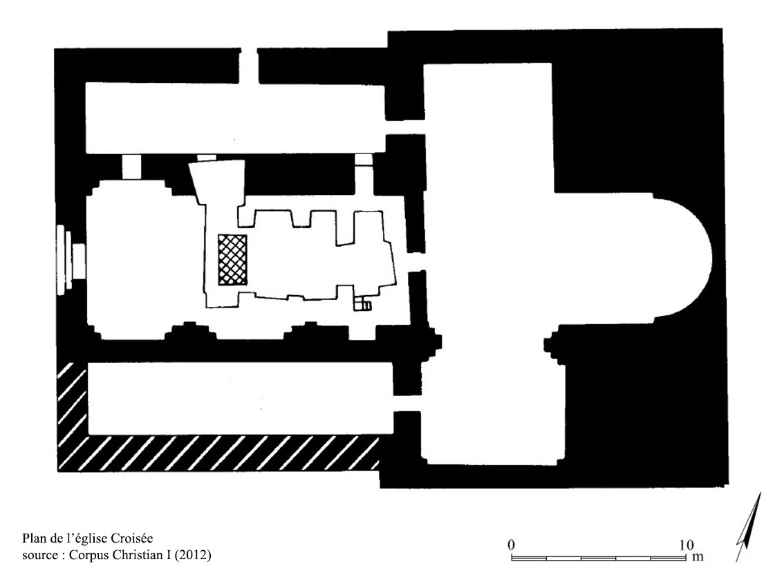
39/ plan de
l’église Croisée |


Documents anciens
Conder/Kitchener (1883), p.149-153. Visite le 9 janvier 1874.
Neby Samwil (Ms).—The ruins include the church of St. Samuel, finished in 11 57 a.d. (see De Vogüe, 'Eglises de la Terre Sainte,' p.339) with scarps and ruins which probably belong to the same period. The Church. The transept and north aisle remain. The nave has been destroyed. The apse has also been apparently destroyed, and a modern wall exists on the east. The cenotaph of Neby Samwil stands about where the middle of the nave would have been. Various later Moslem additions have been made, including the walls round the cenotaph. The minaret stands in the south-east corner of the south side of the transept. Numerous Hebrew inscriptions are written on the plaster of the walls, just outside the chamber, in which the cenotaph stands. They appear quite modern. The tomb of Samuel at this site is recognised in the Jichus ha Aboth (sixteenth century), but is declared to be a false site by Benjamin of Tudela in the twelfth century. The church measured 188 feet across the transept outside ; the nave (not including transept) was 58 feet by 26 feet inside, in three bays. The walls of the church were 7 feet thick.
The arches used are pointed, but broad for their height. The masonry is small and well-dressed, with numerous masons' marks, as shown on the special plan.
Outside the west tower on the south side of the transept there are small drafted stones.
On the north there was a narrow passage outside the church, which appears to have been arched over.
The north aisle, now walled up and made into a mosque, has brackets to support the vaulting, as at Kuryet el 'Enab. The arches are groined and the roof is entire. There appears to have been a small doorway in the west side of the south transept, perhaps leading to a crypt, for a cave is said to exist under the church.
In the north aisle are Hebrew graffiti on the Crusading masonry. They are of some age, as they have been plastered over after being cut. The longest, on a voussoir with a mason's mark (double triangle), records the names of ' Mesha ben David . . ,' ' Levi ben . . .' and ' Shemon ' roughly written in square characters.
East of the church is the modern village containing many ancient fragments, and among others a Crusading chimney. There is a scarp of rock some 5 or 6 feet high running north and south on the east of the village. A narrow trench is cut between this and a sort of platform of rock, which is occupied by buildings. North of the church there is a sort of sunk court about 250 feet north and south by 500 feet east and west, to which the narrow passage leads. On the north-east of this is a flat platform of rock, reached by steps, with a cave below.
East of the platforms the rock is levelled and forms two large shallow reservoirs communicating with one another, the largest some 300 feet side, the smaller, on the east, of irregular shape, 250 feet side. The buildings on the platform do not appear to be very ancient ; they include a long vault with a tunnel roof, and there are two curious shallow recesses in the scarp immediately to the north-east of the passage above mentioned, which may perhaps have been intended for guard-houses.
Lower down the hill on the south-east is a good-sized birkeh cut in rock beside the road. East of this is a ledge of rock from which water trickles out in several places, especially at the ‘Ain Jakûk, where there is a small tunnel 15 paces long and large enough to walk to the end. The water comes out from this to a place where there seems to have been a trough, whence an aqueduct once led. Above this is a small chamber cut in rock, with a door having a pointed arch cut in rock. A litde higher is a small rock-cut stable (compare Khurbet Dustrey, Sheet V., Section B.) for four horses, with rock-cut mangers. It is full of rubbish to the height of the mangers. Further east is another chamber, said to be connected with a spring. It was 4 ½ paces square, with an arched door. The road leading up the hill is ancient. In one part steps well-paved occur. Between Neby Samwîl and Jerusalem the road shows traces
of antiquity, having side-walls of rude blocks or slabs set on end and undressed, and remains of a paving of polygonal stones fitted together, apparently Roman work. The rock in places is levelled to receive this paving.
Visited 9th January, 1874.
Porter (1887), p.139-141. Visite entre 1844 et 1854.
Away beyond the glen towered Neby Samwil, the highest and most conspicuous peak in southern Palestine. Its conical top, crowned with village, mosque, and minaret, forms the only striking object in the northern view from Jerusalem. To it we were now bound, as the first point of interest in our excursion. Diving down into the glen, and then clambering up through terraced vineyards, over rude stone fences, along rocky brakes, startling flocks of artridges here and there, at length we gained the summit of the hill. We gave our panting and foaming horses to the care of a group of wildlooking Arab boys who had been watching our approach from the walls of a half-ruined
tower. The village sheikh was presently at our side with a welcoming saldm, conspicuous in scarlet robe, which now, as in former times, is the badge of royalty or power among the people of Palestine. Several of the village elders stood around him ; and their outer garments, in the brilliancy and variety of colour and embroidery, reminded me of Joseph's coat.
Taking the worthy sheikh into our service, we requested him to lead the way to the top of the minaret. What a noble panorama was there ! I had seen none to compare with it in extent or interest among the mountains of Palestine. It is far wider than that from Olivet, or Gerizim, or Tabor, or any of the peaks round Hebron. Away on the western horizon slept the "Great Sea;" and from this and other commanding points I was able to understand how natural it was for the ancient Israelite to make the word u sea : (yam) a synonym for "west." Along its glittering shore lay the plains of Sharon and Philistia ; the groves of Joppa, looking like the deep shadow of a cloud ; and the towns
of Ramleh, Lydda, and Ekron, like points of light on the smooth gray surface. Nearer were the western declivities of Judah's mountain-range, deeply furrowed with many a dark ravine, and studded with many a castle-like village and ruin. The broad summit of the range was a forest of hill-tops, separated here by a retired upland plain, there by a deep winding glen. On the east, the Jordan and its valley were hid behind the hills of Benjamin ; but the chain of Moab and Gilead rose over them, a vast wall of azure built up against a golden sky, and streaked from base to summit with rich purple shadows. The mountain strongholds of Judah and Benjamin, renowned of yore in sacred story, or celebrated in sacred song, were all there grouped around me:—Gibeon, on its " hill " Beth-horon, guarding the western pass; Beeroth and Beth-el: and away beyond them, rising from a troubled sea of hill-tops, the "rock Rimmon," where the six hundred, the shattered remnant of a guilty tribe, found an asylum ; Raman of Benjamin, crowning its height ; " Gibeah of Saul, now a bare, desolate mount: Kirjath-jearim, perched on the side of " the hill’’ where the ark of the Lord remained for a time in the house of Abinadab ; Bethlehem, overlooking the wilderness ; and Jerusalem, in the midst of all, seated in queenly state, begirt with mountains. That was a panorama which once viewed could never be forgotten. Time cannot deface the picture. It remains photographed on my memory, calling up, as I look fondly back, many a stirring scene of Bible history and many a hallowed association.
Most probably this peak, from which the Western pilgrim has often got in days past, and often gets still, his first glance at the Holy City, was in Tasso's mind when he thus described the effect of " that first far view " upon the Crusaders : ‘’Lo, towered Jerusalem salutes the eyes !
A thousand pointing fingers tell the tale ;
' Jerusalem !
' a thousand voices cry ;
' All hail, Jerusalem !
hill, down, and dale
Catch the glad sounds, and shout,
' Jerusalem, all hail !’’
It was here that Richard of England, having advanced from his camp at Ajalon, stood in sight of Jerusalem ; but, burying his face in his mantle, he uttered the chivalrous exclamation : " O Lord God, I pray that I may never see thy Holy City, if I may not rescue it from the hands of thine enemies ! "
A site so commanding as this could not have been overlooked in the early ages, when every hill had its city or fortress. There is much difference of opinion, however, as to its ancient name. A tradition as old as the sixth century makes it the Ramah, or Ramathaim-zophim, of the Old Testament - the birth-place, home, and burial-place of Samuel. A convent and church were subsequently erected on the spot in honour of the great prophet. The church is said to have been rebuilt by the Crusaders, who supposed this to be the ancient Shiloh. Now, within its shattered walls the Mohammedans have a mosque and a prayer-niche, and perform their devotions beside the traditional tomb of the Jewish prophet. Topography is decidedly against the tradition. There is no evidence to identify Neby Samwil with Ramah.
But there can be little doubt that Neby Samwil is the Mizpeh ("watch-tower") of Benjamin ; the gathering-place of Israel, where the tribes assembled and bound themselves by an oath not to return to their homes till they had avenged on the inhabitants of Gibeah the rights of hospitality outraged by an abominable crime ; where they assembled afterwards, at the call of Samuel, to fight against the Philistines ; where they also assembled to elect their first kins?—and when Saul was chosen there was heard from this peak the loyal cry, " God save the king." It would seem, too, that this is that very " high place of Gibeon " where Solomon offered a thousand burnt-offerings ; and where the Lord, in answer to his prayer, gave him the wisdom that made him a world's proverb. It is therefore a spot of singular interest in connection with some of the most stirring and solemn incidents of Old Testament history.
Baedeker (1893), p.118-119.
On atteint en 20 min. le village de en-Nébi-Samouil. Avant ce dernier, à dr. De la route, se trouvent des réservoirs d'une haute antiquité, taillés dans le sol rocheux ; la source qui les alimente est un peu plus au N. Le village ne compte que quelques maisons, mais les parois de ses murs taillées dans le roc et les grosses et belles pierres à bâtir à l'extérieur de la mosquée, au N.E, témoignent d'une haute antiquité. – De cet endroit on monte en 5 min. au sommet.
En-Nébi-Samouil (prophète Samuel), à 895 m. d'alt, est la montagne la plus haute des environs de Jérusalem. On se trouve ici probablement sur l'emplacement de Mizpah, la célèbre ville des Benjaminites. Asa, roi de Juda, fit fortifier ce lieu pour le défendre contre Israël (I Rois XV, 22). La tradition désigne en-Nébi-Samous comme l'endroit où naquit, habita et fut enterré le prophète Samuel, ce qu'on ne peut toutefois regarder comme certain ; mais on sait que l'emperur Justinien (m. en 565) fit creuser, probablement ici, une fontaine dans le couvent de St-Samuel. Les Croisés prirent cet endroit pour Silo et y construisirent une église « sur le tombeau de Samuel» ; ils nommèrent la montigne mons gaudii (Mont-Joie), parce qu'ils avaient aperçu Jérusalem de Biddou pour la première fois. Il y avait ici au XVIe s. un beau sanctuaire, lieu de pèlerinage fréquenté. Le transept et l'aile N. de l'anc. église des Croisés, construite ici en 1157, sont encore conservés. La mosquée actuelle, dans laquelle on peut entrer (d'une cour) sans difficulté, renferme le tombeau de Samuel. On ne le montre pas volontiers, quoiqu'il soit sacré à la fois pour les juifs, les chrétiens et les musulmans ; on perd peu à ne pas le voir, car le cercueil et l'étoffe qui l'enveloppe sont certainement modernes. Mais on se fera conduire sur le toit de la mosquée, au minaret ; la vue y est magnifique et fort étendue. A dr, au N. d'ed-Djîb s'élève la colline de Ramallah ; en avant, dans le bas, le village de Bîr Nebâla. A l'E, Beit Hanîna ; plus loin du même côté, la colline de Tell el- Foûl ; derrière, dans le lointain, les chaînes de montagnes bleuâtres de la vallée du Jourdain. Au S.E, Jérusalem et le mont des Oliviers. Ensuite, au S, sur une hauteur, Mâr Elyâs ; au- dessus, la cime arrondie de la montagne des Francs, et plus loin, Bethlehem. Le village très rapproché au S. est Beit Icsâ. Au S.S.O, Lifta. A l'O.N.O, Biddou. Dans le lointain à l'O, Ramlé et Jaffa ; on peut apercevoir quand il fait beau, à la fois la mer Morte et la Méditerranée.
|
|
|
|
|
|
|
Le plan du site et de l’église Source : Conder/Kitchener (1883) |
Vue du maqâm Source : Conder/Kitchener (1883) |
Vue du maqâm et du village vers 1900 Source : commons.wikimedia.org |
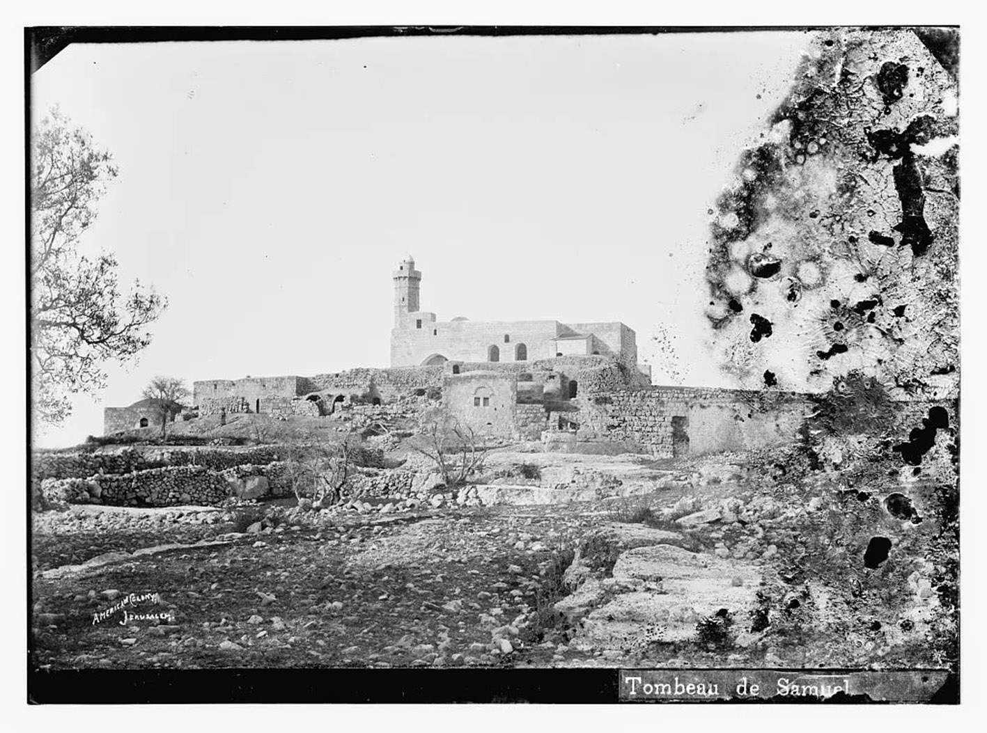
Vue du maqâm et
du village vers 1910 d’après l’American Colony of Jerusalem Source : Library of Congress |
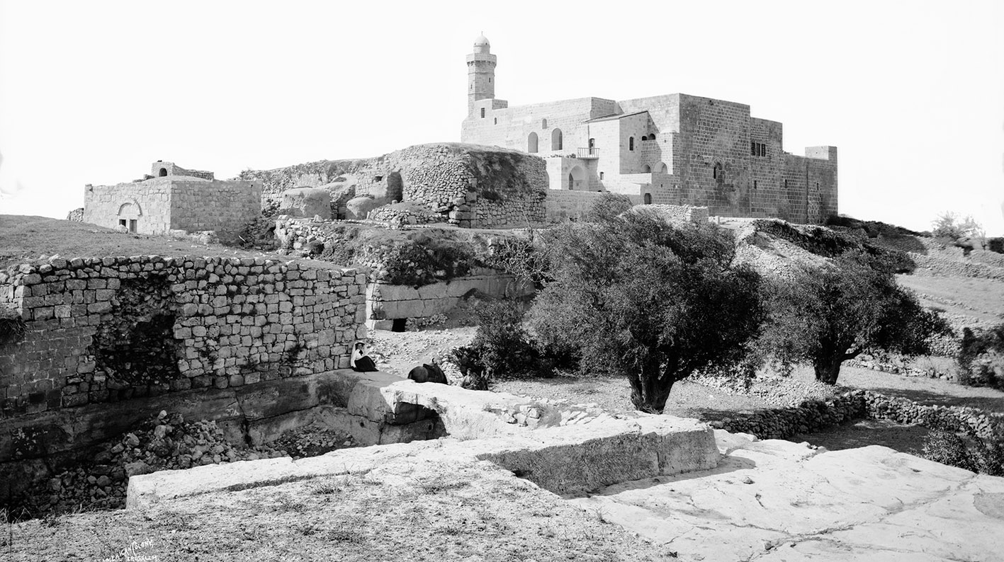
Vue du maqâm
et du village avant 1914 d’après l’American Colony of Jerusalem Source : commons.wikimedia.org |