Khân Jubb Yûsuf (741/1340)
Localisation
Sur la route 90 vers Safed, au sud du kibbutz Ami’ad, en suivant un chemin entre les vergers.
Bibliographie
Burckhardt (1822), p.319 ; Buckingham (1821), p.475 ; Conder/Kitchener (1881), I, p.234, 368 ; Cytryn-Silvermann (2010), p.112-121 ; Guérin (1880), I, p.346-349 ; Kelly (1844), p.336-337 ; Lee/Raso/Hillenbrand (1992), p.55-94 ; Petersen (2001), n°68 ; Porter (1889), p.115
Historique
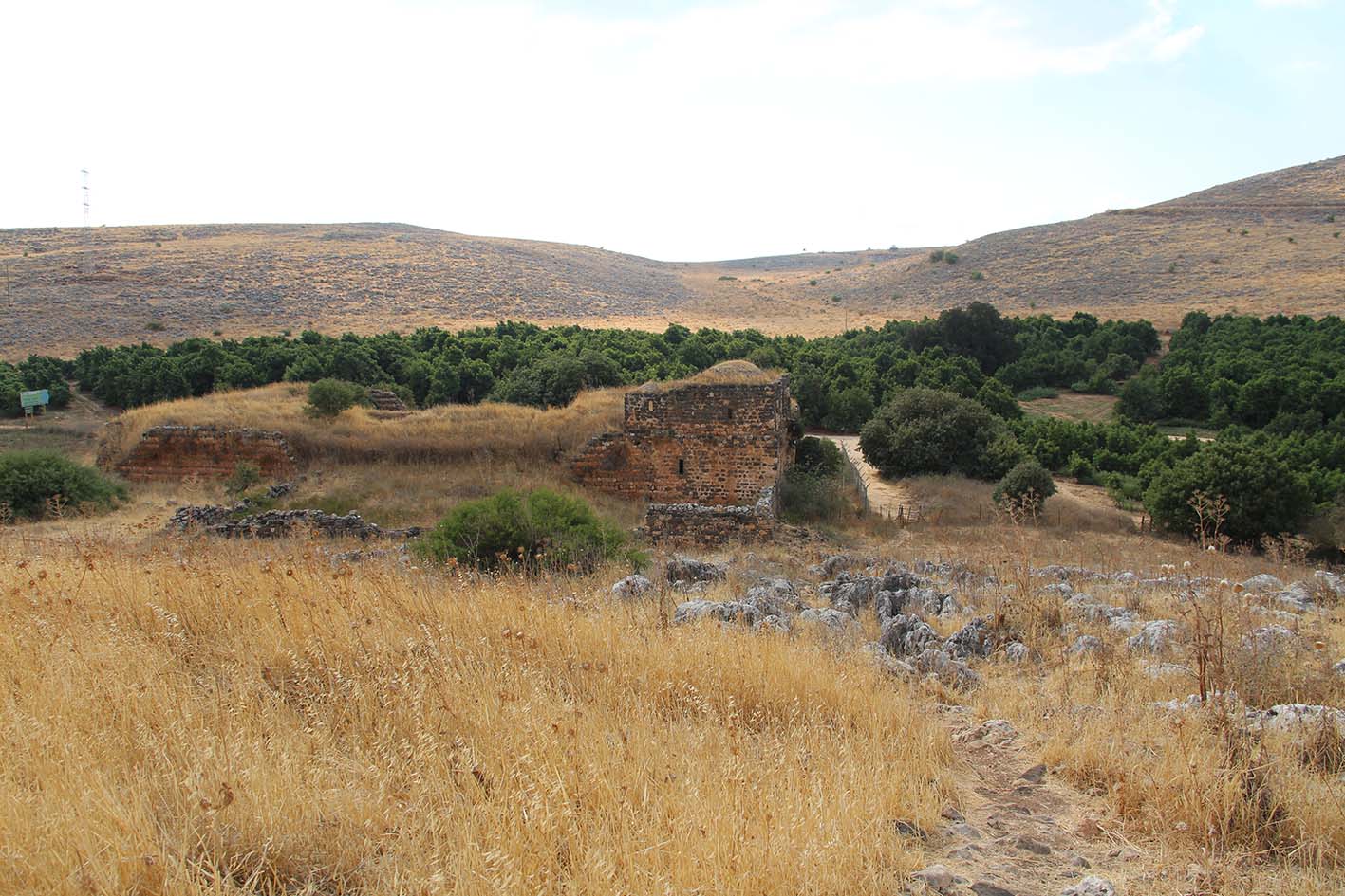
Le site est placé sur l’antique Via Maris à l’emplacement du puits de Joseph (l’actuel édifice à coupole sur la butte, ill.44, 45), il est de plan rectangulaire (47x34m). Il présente plusieurs phases de construction dont des rajouts à l’époque Ottomane.[1] Le plan d’origine[2] semble exclure les premières salles du corridor d’accès et présente des galeries symétriques autour de la cour.
La façade nord du khân est en partie détruite (ill.6-8, 23), à l’angle nord-ouest de l’édifice on trouve une citerne bien préservée et surmontée d’un toit terrasse (ill.10), ce toit fait office de cour à une petite salle de prière située au sud. A l’angle nord-est on trouve les vestiges d’un enclos qui pourrait être plus tardif si l’on s’en réfère à sa maçonnerie peu travaillée (ill.19-22).
L’accès, côté nord, se fait par une arche datée de la période Ottomane et qui semble plaquée contre un accès antérieur (ill.1, 24), il mène à un corridor de 17m flanqué de deux séries de salles voûtées à l’est et à l’ouest et d’un escalier (ill.25-31) desservant l’étage dont il ne reste rien à part un pan de mur côté nord-est perçé d’une grande ouverture et équipé d’un foyer et/ou d’une cheminée. La cour rectangulaire (22x16m) est entourée par une galerie voûtée relativement préservée aux murs alternant basalte et calcaire (ablaq), la galerie est a été modifié ultérieurement par un cloisonnement de l’espace intérieur (ill.33). L’aile sud consiste en une salle centrale (5x5,5m) avec mihrâb faisant office de mosquée, elle est flanquée par deux salles latérales (ill.35-39).
Le khân semble daté de la seconde moitié du 8e/14e siècle.
Le site est mentionné par C.R. Conder et H.H. Kitchener dans le Survey of Western Palestine, il est décrit comme étant utilisé par les voyageurs.[3]
Epigraphie
Pas
d’inscription.
Illustrations
|
|
|
|
|
|
|
|
1/ plan du site |
2/ plan du khân Jubb Yûsuf |
3/ élévations du khân Jubb Yûsuf |
4/ sections du khân Jubb Yûsuf |
5/ vue du site depuis le nord |
6/ vue du khân depuis le nord |


|
|
|
|
|
|
|
|
7/ vue du khân depuis le nord |
8/ vue de l’étage depuis le nord |
9/ vue du khân depuis l’ouest |
10/ l’angle nord-ouest du khân |
11/ la façade ouest du khân |
12/ vue du khân depuis l’ouest |


|
|
|
|
|
|
|
|
13/ vue du khân depuis le sud-ouest |
14/ la cour du khân depuis l’ouest |
15/ vue du khân depuisle sud-ouest |
16/ la façade sud du khân |
17/ vue du site depuis la colline à l’est |
18/ vue du khân depuis l’est |


|
|
|
|
|
|
|
|
19/ vue du khân et de l’enclos à l’est |
20/ la façade du khân depuis l’est |
21/ vue du khân et de l’enclos depuis le nord-est |
22/ le mur d’enclos depuis le nord |
23/ l’étage du khân sur la façade |
24/ l’accès au khân |


|
|
|
|
|
|
|
|
25/ pilier entre le corridor et la salle à l’ouest
de l’accès |
26/ la salle à l’ouest du corridor |
27/ la salle à l’est du corridor |
28/ la 2e salle à l’ouest du corridor |
29/ la 2e salle à l’est du corridor et la
cage d’escalier |
30/ vue de l’angle nord-est de la cour et de la cage
d’escalier |


|
|
|
|
|
|
|
|
31/ la cage d’escalier |
32/ vue de la partie est de la cour |
33/ les salles à l’est de la cour |
34/ les salles à l’est de la cour depuis le nord |
35/ vue de la cour depuis le nord |
36/ la façade sud de la cour |


|
|
|
|
|
|
|
|
37/ une salle au sud de la cour |
38/ la mosquée du khân au sud de la cour |
39/ détail du mihrâb de la mosquée |
40/ vue du côté sud-ouest de la cour |
41/ vue du côté nord-ouest de la cour |
42/ la façade nord de la cour |


|
|
|
|
|
43/ le corridor d’accès depuis le sud |
44/ vue du puit de Joseph (Jubb Yûsuf) depuis le
khân |
45/ la coupole sur le puit depuis l’ouest |


Documents anciens
Burckhardt (1822), p.319. Visite le 22 juin 1812.
June 22d. As there is no Khan for travellers at Szaffad, and I had no letters to any person in the town, I was obliged to lodge at the public coffee house. We left the town early in the morning, and descended the side of the mountain towards the lake ; here the ground is for the greater part uncultivated and without trees. At two hours and a quarter is Khan Djob Yousef (يوسف جب خان), or the Khan of Joseph's Well, situated in a narrow plain. The Khan is falling rapidly into ruin ; near it is a large Birket. Here is shewn the well into which Joseph was let down by his brothers ; it is in a small court-yard by the side of the Khan, is about three feet in diameter, and at least thirty feet deep. I was told that the bottom is hewn in the rock : its sides were well lined with masonry as far as I could see into it, and the water never dries up, a circumstance which makes it difficult to believe that this was the well into which Joseph was thrown. The whole of the mountain in the vicinity is covered with large pieces of black stone ; but the main body of the rock is calcareous. The country people relate that the tears of Jacob dropping upon the ground while he was in search of his son turned the white stones black, and they in consequence call these stones Jacob's tears ( ياقوب دموع ). Joseph's well is held in veneration by Turks as well as Christians ; the former have a small chapel just by it, and caravan travellers seldom pass here without saying a few prayers in honour of Yousef. The Khan is on the great road from Akka to Damascus. It is inhabited by a dozen Moggrebyn soldiers, with their families, who cultivate the fields near it.
Buckingham (1821), p.475. Visite le 13 février 1816.
While I was occupied in taking a hasty survey of these remains, and our guides were enjoying their noon-meal with the Bedouins settled amid these ruins, a small party of travellers arrived from the northward, and halted here for the same purpose as ourselves. On my return to the spot where they were all assembled, I found them warmly engaged in conversation on the news from Damascus, and the dangers of the road. These men, it appeared, were residents of Tiberias who had set out from their own homes two days before to go to Damascus, in order to make some purchases, for which they had taken a sufficient sum of money with them. They were originally six in number and all armed, and they had travelled in safety as far as the Bir-yusef. During their halt there, however, they were attacked by a party of superior numbers, among whom, they said, were several soldiers, but, as they believed, no Bedouins. The result was, that they were stripped both of their money and arms, and some of those who were well-dressed, had their clothes taken from them, but no lives were lost, though two of the party who at first made resistance, were so severely beaten, that they were obliged to leave them behind on the road.
Kelly (1844), p.336-337. Visite en 1841.
Turning away from the consecrated lake, we fixed our eyes on the end of my day’s journey, the towering city of Safed. About an hour from the lake, we came to the great caravan road from Jerusalem to Damascus, and a little off from this to a large khan, in which there is a well-known tradition, as the pit into which Joseph was cast by his brethren before they sold him to the Ishmaelites. In all probability the legend establishing this locality has no better foundation than most of the others in the Holy Land ; but I cannot help remarking, that I do not attach the importance assigned by others to the circumstance of its distance from Hebron, at that time Jacob’s dwelling-place. We know that Joseph’s brethren were feeding their father’s flock at Shechem ; and when Joseph came thither, “wandering in the field, he inquired after his brethren, and a man told him, They are departed hence, for I heard them say, Let us go to Dothan.” If there be any good reason for calling this place Dothan, to me it does not seem at all strange, that in the pastoral state of society which existed then, and still exists unchanged, Jacob’s sons had driven their flocks to a pasture ground two days further on. It happened, just as if to afford a striking illustration of the scene supposed to have taken place here, while we were loitering around the khan, a caravan of merchants came up on their way from Damascus to Egypt ; and the buying and selling of slaves, white or black, being still a part of the trade between these places, I had no doubt that if I had offered my servant for sale, they would have bought him and
carried him to Egypt, where perhaps he would have risen to be a grand vizier.”
Guérin (1880), I, p.346-349. Visite en 1863.
A huit heures trente minutes, après une descente légère, je parviens au Khan Djoubb Yousef, à côté duquel je fais dresser ma tente, sans pousser plus avant ce jour-là, à cause de la violence du rhamsin, dont l’haleine brûlante enflamme l’atmosphère.
Ce khan, actuellement abandonné et tombant en ruine, mesure 60 pas de long sur 46 de large. Les murs en sont très épais et ont été bâtis avec des pierres de moyenne dimension, les unes calcaires, les autres basaltiques. I1 renferme une bonne et grande citerne, où s’approvisionnent d’eau les caravanes qui passent.
A quelque distance au nord, un réservoir, à moitié comblé et construit avec des matériaux peu considérables, affecte une forme carrée et mesure 38 pas sur chaque face. L’eau que les pluies y accumulent tarit d’ordinaire en été.
A l’est-nord-est de ce même khan, s’élève une colline voisine, aux flancs rocheux et sur le sommet de laquelle on remarque une vieille citerne hors d’usage depuis longtemps, qui, d’après une tradition évidemment erronée, serait celle où Joseph aurait été jeté par ses frères avant d’être vendu à des marchands ismaélites qui se rendaient en Egypte.
Conder/Kitchener (1881), p.234. Visite en 1874-1875.
Khan Jubb Yusef (Pf).—It was built on the great Damascus road at the same date as Khan Minyeh, Khan et-Tujjar, and others. It is still in very good repair, and is used as a resting-place by merchants on the road. Long vaults for stabling animals, with small dwelling-rooms and places for prayer, are the principal points in the building.
Near this Khan, on a hill to the east-north-east, is a cistern, which is traditionally that in which Joseph was thrown by his brothers. Dothan however, now called Tell Dothan, is four miles south-west of Jenin, where it was discovered by Van de Velde.
Porter (1889), p.115.
On an upland plain a few miles from the site of Capernaum is a half-ruined khan, rejoicing in the name of Khan Jubb Yusef (“the Caravansary of Joseph's Well”), so called from a tradition that here Joseph was put into a well by his brothers, and afterwards sold to the company of Ishmaelite merchants who were on their way to Egypt. The real spot was at Dothan, nearly forty miles farther south; but there is this semblance of truth in the tradition attached to the place, that there is a deep well, and the caravansary is on the great road leading from Damascus to Egypt ; and in all probability the Ishmaelites crossed the Jordan by the ford where the bridge now stands, and travelled southward along this road. The building is comparatively modern, but being now used as a goat and cow house by the local Arab tribes, and never cleaned out, its open court and adjoining rooms are filled to the depth of several feet with filth and rubbish. It is one of the most abominable resting-places I ever entered. It was a scorching day, however, with no shade outside, and the whole neighbourhood swarmed with Arab flocks and herds and sheperds, and a large caravan besides from the Hauran was resting close to it ; so, having fastened up our horses, we climbed to a small upper chamber, which was fortunately empty, and there partook of our mid-day meal. It was with some difficulty our servants kept out the Arabs and the leaders of the caravan, who are always insolent and always dirty. They deemed it safer not to attempt force, for though they were numerous, our servants were determined and well
armed; we were, therefore, permitted to remain alone, while our friends glared at and cursed us from without. Such is life in the by-ways of Palestine. There is no security for peaceful travellers. The words of Jeremiah seem to be fulfilled, “Spoilers are come upon all high places thorugh the wilderness…No flesh shall have peace” (xii. 12).”