Birket Salomon/Bassins de Salomon (n.d.)
Localisation
A 5km au sud-ouest de Bethléem, le long de Berk Sulaiman road à al-Khadr.
Bibliographie
Adams (2019), p.15-35 ; Adawi (2005) ; Amit
(2002b), p.253-266 ; Amit/Gibson (2014), p.9-41 ; Berchem (1922), p.240-248 ;
Billig (2002), p.245-252 ; Billig (2014) ; Billig (2015) ; Billig/Dolinka
(2013) ; Buckingham (1821), p.224-226 ; Guérin (1869), III, p.115-117 ;
Gurevich (2020), p.268-281 ; Lemire (2011), p.103-165 ; Masterman (1902),
p.87-112 ; Mazar (2002), p.211-244 ; Pierotti/Bonney (1864) ; Pococke
(1745) ; Porter (1887), p.132-134 ; Saulcy (1865) ; Schick (1878), p.132-178 ;
Warren (1876) ; Warren/Conder (1884) ; Whitty (1864) ; Wilson (1881), I, p.138-139
; Wilson/Warren (1871), p.233-267 ; Zilberbod (2011)
Site internet
https://sketchfab.com/3d-models/the-lower-pool-at-solomons-pools-bead909e08dc4f458052c0a7923b07d1
Historique
Les bassins de Salomon regroupent trois bassins rectangulaires approvisionnant Jérusalem en eau (ill.19), ils sont creusés à différents niveaux dans le wadî al-Hoch, un affluent du wadî al-Urtas.
Ces bassins reçoivent l’eau de quatre sources environnantes (ill.1, 2) :
‘Ain Saleh (810m d’altitude), à 200m au nord-ouest du bassin Supérieur.
‘Ain Farujeh (750m d’altitude), située dans la partie orientale du bassin Inférieur, fournit aussi l’aqueduc Inférieur.
‘Ain ‘Atan (760m d’altitude), située sur le tracé de l’aqueduc Inférieur, n’est pas connecté aux bassins.
‘Ain Buraq (805m d’altitude).
Et de deux aqueducs (ill.1, 2) :
l’aqueduc al-‘Arrûb avec les sources ‘Ain Saleh et ‘Ain Buraq qui fournissent le bassin Intermédiaire.
l’aqueduc du Wadî al-Biyar qui apportent l’eau depuis les sources et les bassins plus élevés au sud jusqu’au bassin Supérieur.
A cela il convient d’ajouter les eaux de pluie collectées depuis la plaine de Khadr.
L’aqueduc Supérieur et l’aqueduc Inférieur envoient l’eau à Jérusalem depuis ces bassins.[1]
Les trois bassins sont désignés comme suit :
Le bassin Supérieur 118x71m, et 9/11m de profondeur (ill.1-3).
Le bassin Intermédiaire 135x50m (à l’ouest)/76m (à l’est) et 10/12m de profondeur (ill.4-10).
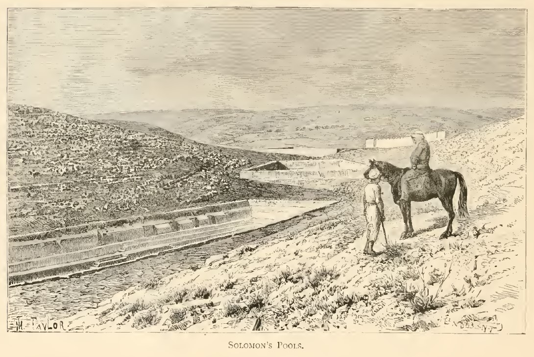
Le bassin Inférieur qui est le plus grand des trois : 179x46m (à l’ouest)/61m (à l’est) et 23m de profondeur (ill.11-18). Etanchéifié plusieurs fois, une partie du mur nord du bassin s’est effondré récemment laissant entrevoir les couches antérieures du bassin (ill.15, 16). Ce bassin a été creusé dans un ancien wadî suivant sa courbe ce qui lui donne cette forme irrégulière, à l’intérieur la roche a été excavé en terrasses et des contreforts on été taillés, un muret sépare ce bassin en deux (ill.17). Le mur nord-ouest montre plusieurs additions architecturales dont un canal et des escaliers (ill.12-14). Le mur est du bassin semble fonctionner comme un barrage.
La première phase de construction de ce bassin, le creusement dans la roche, date de la période Romaine, la deuxième phase comprend la construction des murs et l’ajout des contreforts internes ainsi que l’aqueduc parallèle au mur nord. Une phase de renforcement et de rénovation du bassin est associée à la période Mamluk notamment sous le règne du sultan Qaytbay (r.6 rajab 872/31.I.1468 – 27 dhu’l-qa’da 901/7.VIII.1496) vers 1483. Felix Fabri qui visite la Palestine entre 1480 et 1483 s’arrête sur le site et en fait une longue description.[2]
Les bassins sont restaurés par le sultan Ottoman Soliman entre 1541 et 1568, une forteresse le Qal’at al-Burak est élevée en 1601 pour protéger le site.[3] Tout le système est ainsi restauré par ce sultan vers 943/1536 et ses successeurs[4], la ville de Jérusalem est aussi dotée de plusieurs fontaines.[5]
Le site a été largement rénové sous le Mandat Britannique.
Epigraphie
Pas
d’inscription.
Illustrations
|
|
|
|
|
|
|
|
1/ plan des bassins de Salomon et des installations
environnantes |
2/ schéma du système d’aqueduc vers Jérusalem |
3/ le bassin Supérieur depuis l’ouest |
4/ le bassin Intermédiaire depuis l’ouest |
5/ le collecteur d’eau entre les bassins Supérieur
et Intermédiaire |
6/ l’angle sud-est du bassin Intermédiaire depuis le
nord |


|
|
|
|
|
|
|
|
7/ le bassin Intermédiaire depuis le nord-ouest |
8/ le bassin Intermédiaire vers le nord-est |
9/ le bassin Intermédiaire depuis l’ouest |
10/ le mur de retenu est du bassin Intermédiaire |
11/ le bassin Inférieur depuis le sud-est |
12/ la partie est et le déversoir du bassin
Inférieur depuis le sud |


|
|
|
|
|
|
|
|
13/ vue du déversoir |
14/ l’angle nord-est du bassin Inférieur depuis le
sud |
15/ le mur nord du bassin Inférieur après les
réparations de la brêche |
16/ vue du mur nord du bassin Inférieur depuis le
sud avec les contreforts |
17/ le bassin Inférieur depuis l’est avec ses
terrasses et son muret de séparation |
18/ le déversoir du bassin Inférieur depuis l’est |


|
|
|
19/ plan du système d’approvisionnement en eau de
Jérusalem |

Documents anciens
Guérin (1868), III, p.115-117. Visite en 1852, 1854 ou 1863.
Décrivons maintenant en peu de mots les trois vasques que nous avons déjà plusieurs fois mentionnées. Elles occupent une vallée assez étroite, resserrée entre des montagnes rocheuses, et qui s'abaisse progressivement, et par trois étages distincts successifs, de l'ouest à l'est.
La première, c'est-à-dire la vasque supérieure ou la plus occidentale, mesure cent trente-huit pas de long, sur une largeur de soixante et dix-huit à l'ouest et de quatre-vingt-deux à l'est. En partie creusée dans le roc et en partie construite, elle est soutenue intérieurement par des contre-forts, afin de mieux résister à la poussée des terres. Un seul escalier permet d'y descendre à l'angle sud-est. Le mur, du côté de l'est, a un mètre trente centimètres de large dans sa partie supérieure ; mais il est bien plus épais dans les assises inférieures, que la terre recouvre, et il renferme intérieurement une chambre dans laquelle je n'ai pu pénétrer.
La deuxième vasque ou vasque intermédiaire est située à soixante pas au-dessous et à l'est de la précédente. Sa longueur est de cent cinquante-huit pas, et sa largeur de quatre-vingt-cinq à l'ouest, sur soixante-deux à l'est. Elle est en grande partie creusée dans le roc vif et par différents étages en retraite les uns sur les autres, ce qui oppose à la poussée des terres une résistance beaucoup plus forte que si l'excavation avait été verticale de haut en bas. Aussi ce bassin n'est-il pas soutenu intérieurement par des contre-forts dans le sens de sa longueur, cet appui lui étant inutile. On y observe deux escaliers taillés dans le roc, l'un à l'angle nord-est, l'autre à l'angle nord-ouest. C'est près de ce dernier angle aussi qu'un petit canal, provenant de la fontaine scellée, déverse ses eaux dans le bassin, après avoir longé latéralement la première vasque. Le mur de ce second réservoir, du côté de l'est, est extrêmement épais et soutenu lui-même par un deuxième mur en talus, dont la partie supérieure forme un chemin. Ce talus affecte l'apparence d'une pyramide, les gros blocs qui le composent étant placés en retraite comme les gradins d'un escalier. Il contient de même, vers le bas, une chambre intérieure, dont j'ai trouvé l'entrée obstruée.
Plus à l'est encore et à un niveau inférieur, à la distance de quatre-vingt- cinq pas de la deuxième vasque, s'étend la troisième, qui mesure deux cent quatorze pas de long, sur une largeur de cinquante à l'ouest et de soixante et quinze à l'est ; elle est en partie creusée dans le roc et en partie construite. Deux escaliers y ont été placés, l'un à l'angle sud-est, l'autre à l'angle nord-est.
Beaucoup plus profonde que les deux précédentes, car vers le centre, et surtout vers l'est, sa profondeur doit dépasser quinze mètres, cette vasque est étayée au dedans par de nombreux contreforts. Dans son flanc méridional, une ouverture laisse passage à un canal qui, pendant l'hiver, lui amène les eaux pluviales découlant d'une montagne voisine. Derrière cet immense réservoir, vers l'est, un énorme mur de soutenement, bâti avec de beaux blocs disposés en gradins, contient, dans son épaisseur, un corridor que j'ai trouvé ouvert. M'y étant engagé, je suis parvenu bientôt à une chambre voûtée en plein cintre et construite en pierres de taille très-régulièrement agencées entre elles, qui m'ont paru reposer les unes sur les autres sans ciment. Cette chambre doit être identique probablement avec les deux autres qui sont pratiquées dans l'épaisseur des murs analogues qui soutiennent, vers l'est, les deux précédentes vasques. De cette troisième chambre, l'eau du réservoir inférieur, qui lui-même recueille celle des deux premiers, lesquels lui servent comme de filtres, s'écoule plus bas, par un conduit qui la traverse, vers l'aqueduc dont j'ai déjà parlé, et que je décrirai dans la suite plus amplement.
On sait, comme je l'ai dit, que la tradition fait ces trois vasques contemporaines de l'époque de Salomon. Or cette tradition, loin de me paraître improbable, me semble, au contraire, réunir en sa faveur une grande vraisemblance. Ce n'est pas que j'attribue à ce prince certaines parties de ces superbes bassins, qui attestent une restauration postérieure. Nous savons, en effet, par l'histoire, qu'ils ont été plusieurs fois réparés. Par exemple, l'ancien enduit dont ils étaient revêtus intérieurement a presque entièrement disparu pour être remplacé par un ciment arabe ; mais la structure générale de ces réservoirs, soit taillés dans le roc, soit bâtis avec des blocs de grandes dimensions, principalement dans les assises inférieures, accuse un travail qui paraît judaïque et bien antérieur à l'époque romaine, et surtout à l'époque arabe. Avec la plupart des voyageurs, je m'en tiens donc, jusqu'à nouvel ordre, à la tradition, et je vois là encore presque intact l'un des grands ouvrages dont se glorifiait Salomon lui-même, lorsqu'il disait, dans l'Ecclésiaste :
« Magnificavi opera mea. J'ai fait des choses magnifiques... ».
Baedeker (1876), p.252-255.
The so-called Pools of Solomon, three in number, are situated in a small valley sloping towards the E. at the back of the castle. The highest of them is bounded on the W. side by the road leading from Jerusalem to Hebron. As the valley descends abruptly towards the E., the reservoirs had to be constructed in steps, as an embankment of great size would have been necessary to confine the water of a single large reservoir. The lowest of the three was always filled first, and the two others in succession, and they were emptied in the same order, each, when empty, being refilled from the one above it. The three ponds do not lie exactly above each other. The second is 53 yds. distant from the highest, and 52 yds. from the lowest, and is about 19 ft. below the one and the same height above the other. At the lower (E.) end of each pond a wall is built across the valley, as is the case with the Sultan's Pool. The Highest pond is 127 yds. long, 76 yds. wide at the top and 79 yds. below, and is at the lower (E.) end 25 ft. deep. It is partly hewn in the rock, and partly enclosed by masonry, flying buttresses being used for the support of the walls. A staircase descends in the S.W. corner. The Central pool is 141 yds. long, 53 yds. wide at the top and 83 yds. below, and is 38 ft. deep. It is almost entirely hewn in the rock, and stairs cut in the rock descend in the N.W. and N.E. corners. In the N.E. corner is the mouth of a conduit from 'Ain Salih (see above). The E. wall of the Teservoir is very thick, and is strengthened by a second wall with a buttress in the form of steps.
The Lowest pond, the finest of the three, is 194 yds. long, 49 yds. wide at the top and 69 yds. below, and is at places 48 ft. deep. It is partly hewn in the rock, and partly lined with masonry. Stairs descend in the S.E. and N.E. corners. The inner walls are supported by numerous flying buttresses. On the S. side there is a conduit for the reception of rain-water. The lower wall (E.) is built of large blocks in the form of steps, and is penetrated by an open passage leading to a chamber. On the W. side of this lowest chamber is the entrance to a channel from which the water of a spring situated under the bottom of the pool (‘Ain Farujeh) flows to the N. E. through the chamber into another channel which brings a supply of water from the neighbouring ‘Ain Ethan, situated on the S. ; the united streams are then conducted towards Bethlehem. Besides these and the ‘Ain Salih, there is sf fourth spring in the
castle, and there are thus four springs in all near the pools, all independent of each other.
By whom were these pools constructed ? The lower spring has probably been rightly identified with the spring of Etam, from which, according to the Talmud, the Temple at Jerusalem was supplied with water. The name 'Solomon's Pools' is based upon Eccles. II. 6 ('I made me pools of water, to water therewith the wood that bringeth forth trees'), but that passage does not in the least prove that the gardens of Solomon were situated in this valley, although the bottom of the valley, where it is irrigated by the springs, is remarkably fertile. There is just as little ground for attributing the Jerusalem conduit to Solomon. Josephus records that Pontius Pilate began to construct a conduit with money belonging to the Temple, intending to bring water to Jerusalem from a distance of 400 stadia, but that this proceeding gave rise to an insurrection. Now 400 stadia are about 48 miles. The account may be exaggerated, but springs still flow from other directions into this conduit, and Major Wilson discovered a second aqueduct (recently examined and measured by Schick), which comes from the Wady 'Arub, near Hebron. Another which comes from the Wady Biâr (valley of wells), 1 hr. to the S. of the pools, has long been known. These aqueducts are generally carried horizontally along the mountain-slopes, with a slight fall only, but there is a remarkable portion between Bethlehem and Jerusalem which proves that the ancients were acquainted with the principle of the rise and fall of water when confined in pipes. In any case the reservoirs were constructed with a view to the water being carried to a distance, and not merely for the irrigation of the Etam valley. Though perhaps not so old as the time of Solomon, the pools are unquestionably of great antiquity. They were not discovered by the pilgrims until a comparatively late period.
Wilson (1881), I, p.138-139. Visite au printemps 1865.
We now pass up the tiny glen to El Burak (Solomon's Pools), by the side of the direct road from Bethlehem to Hebron. Immediately on leaving the enclosed gardens barrenness resumes its sway. The valley was once full of oaks of large size, and stumps may here and there be seen, now sought for and dug up for firewood. The pools are marked at a distance by the great square castle at the north-west corner of the upper one—a late Saracenic structure serving the purposes of khan and barracks for a few soldiers. The pools are three in number and in steps, each at a considerably lower level than the one above it, and are formed by walls of massive masonry stretching across the valley. They are chiefly hewn out of the native rock, the upper one especially being considerably heightened by masonry strengthened by buttresses. There is a space of over fifty yards between each pool. We can see at once the reason for constructing three basins, for a single reservoir to hold so large a supply would have demanded an embankment of enormous strength. The tanks are all widest at the lower end, one hundred and twenty-seven, one hundred and forty-one, and one hundred and ninety-six yards in length respectively, and varying in width from fifty-three to eighty yards, and twenty-five, thirty-eight, and forty-eight feet deep respectively. To enable the pools to be cleaned and water to be drawn on the spot when not quite full, there are flights of stairs inside the lower end of each. Not only are the supplies from several springs, near and distant, carefully conducted by subterranean channels into the pools, but there are also channels for the collection and conveyance of rain-water, so that nothing shall be lost. The " sealed spring," as it is called, from the belief that it is identical with the " sealed fountain" of Solomon's Song, is the most important source of supply. It rises in a field a little to the west, is trapped in a vaulted chamber, and conveyed by a subterranean channel into the upper pool. Besides this there are at least three other fountains which by a similar contrivance feed the reservoir. From the lower end of the lower pool the great aqueduct, by a winding course along the hillsides, conveys the water to Jerusalem, to Mount Moriah, immediately under the Temple. There are, however, according to Mr. Drake, in reality six aqueducts connected with Urtas and Solomon's Pools. The first, coming from the south, proceeds to El-Burak, and is of a different and probably earlier style of masonry than the continuation to Jerusalem, which is the second, or low-level aqueduct ; this is composed of earthen pipes set in masonry, with air-holes at intervals to relieve the pressure. The third is the high-level aqueduct which enters Jerusalem by the Birket Mamilla, near the Jaffa Gate. A fourth aqueduct in the same direction is entirely ruined, while the fifth and sixth supplied villages or towns to the eastward ; one of them can be traced nearly to Jebel Fureidis. It is stated that several portions of these aqueducts prove that their builders were aware of the fact of water finding its level when confined. It is generally now believed that these are all of Roman work, and are the very aqueducts referred to by Josephus as being built by Pontius Pilate, who used for that purpose the moneys brought into the Temple treasury as " corban." But however this may be, the pools are undoubtedly of great antiquity, and the knowledge shown of the principle of the rise and fall of water when conveyed in pipes does not look like merely Roman engineering.
Porter (1887), p.132-137. Visite entre 1849 et 1859.
Solomons Pools. - A short ride up the glen from Urtas brings us to a basin-shaped depression in the mountain-range, in the bottom of which lie Solomon's Pools. They are partly excavated in the rocky bed of the vale and partly built of large hewn stones. They are three in number, of great size—each being nearly one hundred and fifty yards long, by half as much in breadth, and about forty feet deep. They are so arranged on the natural slope of the ground that the bottom of the upper pool is higher than the surface of the next, the object evidently being to collect and store the greatest possible quantity of water.
The source from which they are supplied is a subterranean fountain some distance above them on the hill-side. The only visible mark of this fountain is an opening like the mouth of a well, generally covered with a large stone. The internal arrangements are very ingenious, and give one the impression that the intention was to conceal the spring. Water in the East is the most valuable treasure. Without it there can be no fertility - indeed, there can be no life. Hence we find that some of the severest struggles the patriarchs had when they roamed over Palestine was for the possession of wells. The opening here leads, at a depth of four yards, to a vaulted chamber, evidently of the
highest antiquity. Adjoining this chamber is another. There are four fountains in the chambers, from which the water is carried through a subterranean tunnel to the corner of the upper pool. Here the stream is divided, a portion flowing into a large vault, and thence through a duct into the pool. Another portion of the water, however, is led off, ere it reaches the pool, by an aqueduct, along the hill-side to Bethlehem and Jerusalem. This aqueduct is so constructed that any surplus water can be let off in passing into the second and into the third pool, while a duct joins it from the bottom of the third pool, so as when necessary to give the fullest available supply. The object of this complicated system of springs, vaults, and ducts, was to secure a constant supply of water for Jerusalem. That in ordinary times the water might be as pure as possible, the aqueduct was connected with the fountain-head. When the fountain yielded more than was needed, the surplus passed into the pools in succession. When the supply from the fountain was not sufficient, it was augmented, as required, from the great store in the pools. Another subterranean aqueduct has been discovered which brings, or rather brought in olden times, a further supply to the lower pool, from fountains amid the hills farther south.
The antiquity of these great reservoirs and of all the annexed engineering works cannot be questioned. Their extent, solidity, and wonderful ingenuity in construction, show that they could only have been executed in times of peace and prosperity. Their distance, too, from Jerusalem, which they were intended to supply with water, proves that the power of the rulers of the city must at the time have been paramount. The fountains were " sealed ;" designed to be, when thus enclosed, and to remain in after times, concealed from view and unknown to all invaders. The aqueduct itself, though runningover hills and across ravines for some ten miles, is not easily seen by passers by. It is nowhere raised on arches except in crossing the Valley of Hinnom to Zion.
Strange to say, we find no reference to these gigantic and most useful works in the Bible. That they must have existed during the Jewish monarchy, and when the Temple services were conducted with all their pomp and ceremony, is evident ; for in no other way, at least in none hitherto discovered, could a sufficient supply of water have been obtained. Josephus tells us that at Etam, to which Solomon was in the habit of taking a morning drive from his palace, were gardens, and fountains, and streams of water ; and 'Etam, as we have seen, is only a short distance below the Pools. Does not the historic statement of Josephus, connected with the local topography which I have endeavoured to describe, illustrate the striking passage in the Book of Ecclesiastes, where Solomon says, with a display of genuine Oriental boastfulness, " I made me great works... I planted me vineyards : I made me gardens and orchards, and I planted trees in them of all kinds of fruits: I made me pools of water, to water therewith the wood that bringeth forth trees...
So I was great, and increased more than all that were before me in Jerusalem : also my wisdom remained with me.
Beside the upper pool is a large building, half castle half caravansary, of Saracenic origin, now occupied by the guardian of the Pools. Near it one generally sees some members, male and female, of the Taamirah tribe. The accompanying engraving is a faithful representation of two of the women, in their loose, flowing desert costume, with their long plaited hair, rings, nose-jewels, and large bracelets. The style in which the baby is slung, with a bundle of clothing over the shoulder of the one, and the pipe held in the hand of the other, is quite characteristic of those desert belles. In the background we observe the Saracenic castle, and the Pools near it to the right.
a.d. 1300. The aqueduct has been traced to the great cisterns beneath the Haram.
Major Wilson's more recent researches have brought to light no less than three ancient aqueducts from the hill country beyond Bethlehem to, or towards, Jerusalem. The first, or low-level aqueduct, he says, "derives its supply of water from three sources : the Pools of Solomon, Ain Etam, and a large reservoir in the Wady Arrub." On leaving the reservoir it " follows a winding course amongst the hills, passing Tekoa, before it reaches Urtas." Its course is below the lower pool. From thence to Jerusalem " it has a serpentine course of thirteen miles, and passes through two tunnels, one under the village of Bethlehem and the other not far from the city." A section of a much older
aqueduct, on the same level, was discovered by Captain Warren, tunnelled in the rock round the southern brow of Zion. It was evidently of Jewish origin.
The high-level aqueduct derived its supply from several sources among the highlands between Etam and Hebron. The most distant of these has not yet been discovered, but the aqueduct has been traced as far south as Wady Arrub. From that place it is carried along the sides of valleys and through ridges of rock, passing between the upper pool and the " sealed fountain ;" the latter of which, as Major Wilson observes, it probably tapped.
Thence it runs along the hill-side above Bethlehem and past Rachel's Tomb, near which it crosses a valley in a tube formed of large blocks of stone perforated, cemented together, and embedded in rubble masonry. The tube is fifteen inches in diameter. Further north it has not been traced, but it is supposed to have run along the Valley of Rephaim, and to have flowed into a large reservoir lately discovered on the high ground west of the Jaffa Gate of Jerusalem. When excavating for the foundations of the Russian convent, the remains of a very ancient conduit were discovered ; and subsequently a section of it was laid bare within the city, at the house of the Latin Patriarch. Major Wilson suggests that this may be the termination of the high-level aqueduct.
" The third aqueduct," says Major Wilson, " was only seen at one place,—to the south of Rachel's Tomb. It was said to follow the northern slope of the ridge lying between Wady Urtas and Wady er-Rahib, and to have done thisust have passed under the divide near the head of the Pools by a tunnel." These particulars of ancient engineering works are most interesting from an antiquarian and also from a scriptural point of view. They give us a clearer insight into the talent and enterprise of the Jews. They show, too, in all probability, something of the character of those " great works " of which Solomon proudly boasts, and upon which the Queen of Sheba looked with profound astonishment. In their engineering, as well as in architecture and art, the Jews may have been instructed by the Phoenicians, whose genius and skill were famed over the world.
Be this as it may, one is always deeply impressed, when travelling through Bible lands, with the minuteness of topograjmical details, the graphic descriptions of scenery, the vivid sketches of Eastern work, life, character, and costume, given by the sacred writers. Often in a sentence or two a picture is drawn which has the accuracy of a photograph, combined with the rich colouring of a Claude or a Rembrandt. The pictures of David, Samson, Solomon, and John the Baptist, are drawn with a master hand ; and when we read the record of their lives and actions on the spot, the old incidents and characters appear to group themselves before the mind's eye. One sees a David in every
shepherd in the wilderness of Judah, and a John the Baptist in every Taamirah chief clothed in his cloak of camel's hair with a leathern girdle about his loins.
|
|
|
|
|
|
Plan des Bassins de Salomon au 18e siècle Source : Pococke (1745) |
Vue des Bassins de Salomon depuis le nord vers 1847 Source : Stebbing (1847) |
Vue des Bassins de Salomon d’après J.L. Porter Source : Porter (1887) |
Vue des Bassins de Salomon depuis le nord-est
d’après la Detroit Publishing Company vers 1900 Source : Library of Congress |